Updated: March, 2024
There are two completed sections of greenway and a partial design for a third,
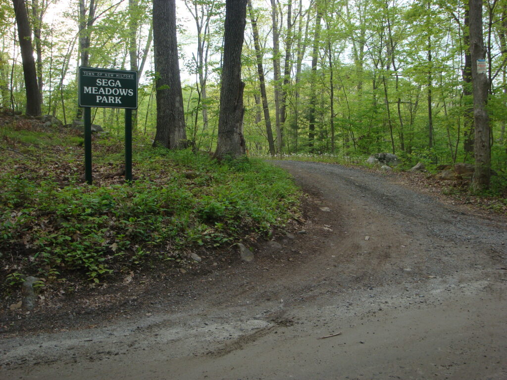
COMPLETED SECTION ONE
Sega Meadows Park to Gaylordsville (the northern end)
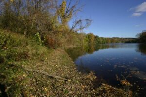
This section of New Milford River Trail greenway currently extends for five miles from the Boardman Road entrance to Gaylordsville. It runs for 1½ miles on a crushed, gravel surface through Sega Meadows Park, where it joins the unpaved and lightly trafficked River Road, and continues for another 3½ miles to the center of Gaylordsville at Route 7 by the New Country Deli Store.
Parking
Limited parking is available at the southern trailhead (next to Boardman Bridge). Another lot is located across the river, on Route 7 between the modern Boardman Bridge and the parking lot for a restaurant. There is a much larger parking lot at the northern entrance to Sega Meadows Park on River Rd. (Take River Road to where it becomes dirt. Go across the train tracks. The entrance will be on the left).
Update 3/2024: Starting May 1- October 31 Parking permits are required to park at the northern parking lot of Sega Meadows Park (on River Road), as well as along River Rd. No parking permit is required for the southern gate (on Boardman Rd), or in the lot on Route 7 between Boardman Rd and Good Eats Restaurant in front of the historic Old Boardman Bridge. Seasonal and 1-day permits are free and available to anyone from the Mayor’s Office in Town Hall, 10 Main St, New Milford CT 06776. Unpermited parked vehicles will be towed away. No swimming or fires are permitted along River Rd and no dumping of trash. Kayaking, canoeing and fishing are still allowed.
The Terrain
The trail itself is relatively flat, with only a couple of small hills. It is well-suited to walking, running, or bicycling (with anything other than a road-racing bike). The 10-mile round trip to Gaylordsville is an easy ride for most families.
Note: There are no public bathrooms along the greenway until you reach Gaylordsville. There are also no trash receptacles. Plan accordingly.
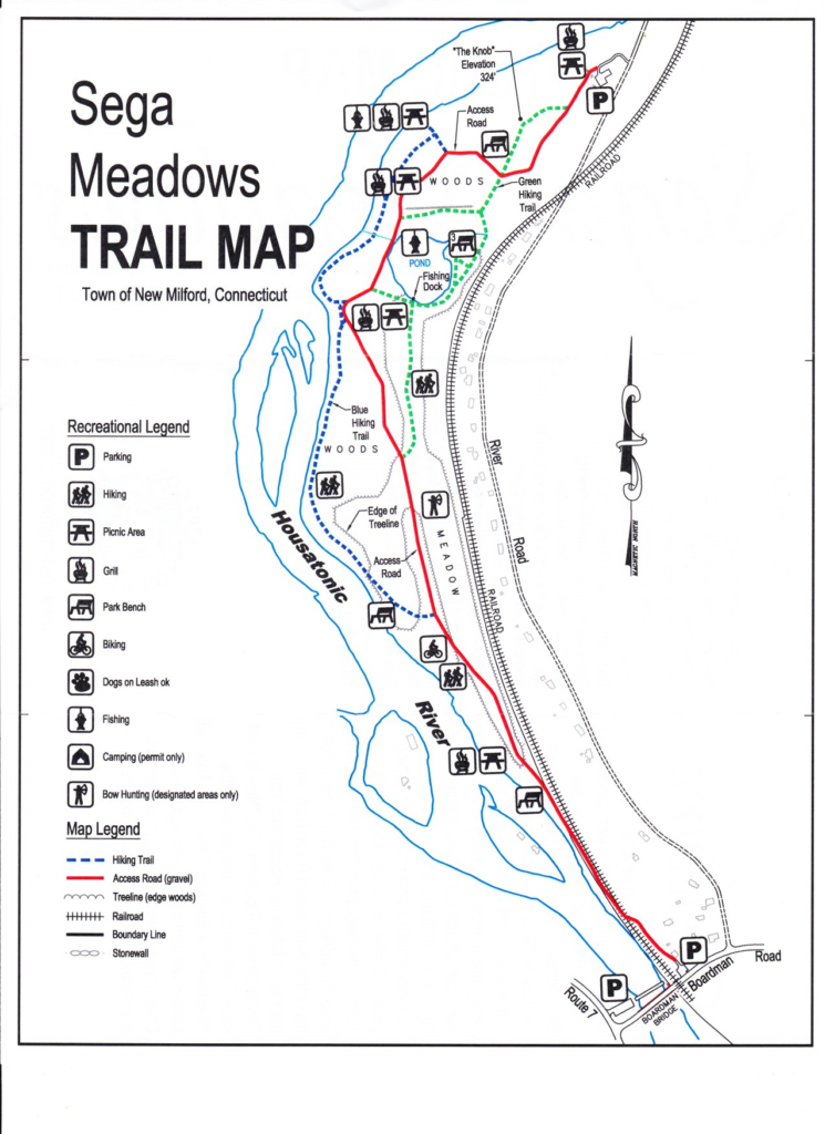
Sega Meadows Park Map
Parking on Boardman Road
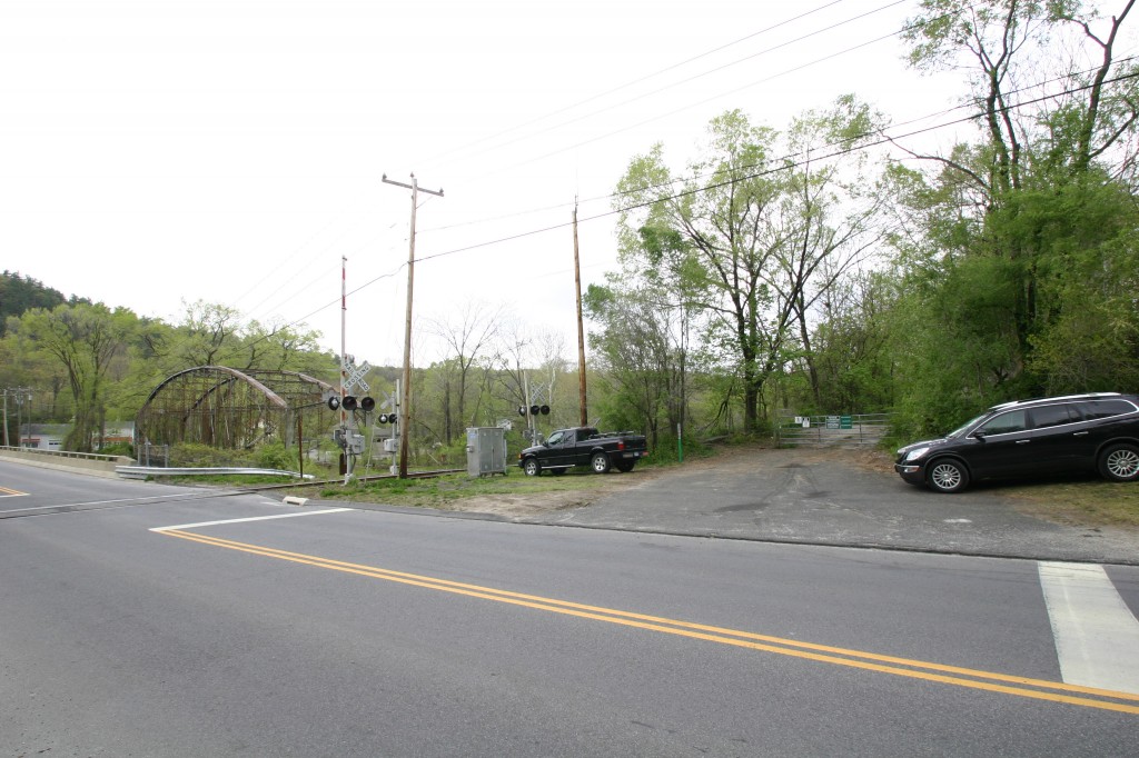
Northern entrance to Sega Meadows Park on River Road
COMPLETED SECTION TWO
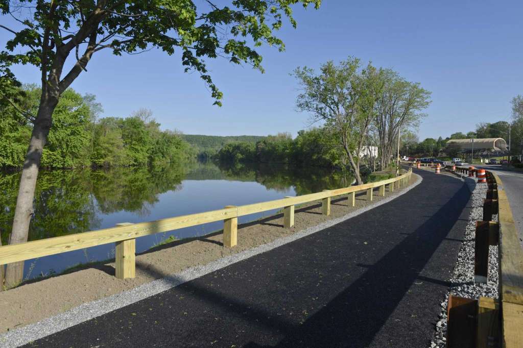
The Riverwalk at Young’s Field Park
In the fall of 2016, the town started another segment of the New Milford River Trail greenway along the river front at Young’s Field Park in the downtown section of New Milford within eyeshot of the historic Village Green that was completed in the spring of 2017. With $180,000 in funding from the Housatonic River Natural Resources Restoration Settlement Fund (GE Settlement Fund), Landfill Settlement Fund (Waste Management Funds), and our generous supporters, this riverfront recapture project stabilized the embankment at Young’s Field, allowed for invasive overgrowth and dead trees to be removed, native species plantings to be added, along with a fishing dock and benches to take in the new, beautiful view of the Housatonic River, and a 1/4 mile, environmentally-friendly, paved surface to be installed that allows for bikers, walkers, runners, wheelchairs and strollers.
This section of New Milford River Trail is connected to the Village Green via Patriot’s Way (accessible by using a crosswalk at the northern end), or by walking through Young’s Field Park to a staircase located by the skateboard park.
DESIGN OF PHASE I*:
Boardman Road to the MedInstill Entrance Drive
In September of 2021, using funding the town received from a CT Recreational Trails Grant, the following was completed by SLR Consulting:
- Progression of design development plans to 70% completion
- Coordination of structure detailing, particularly the boardwalks
- Refinement of earthwork and grading to limit fill within the floodplain
- Review and coordination of inland wetlands application
- Preparation and submission to inland wetlands including drawing set, soil report, & consent letter
- Field work for NDDB identified species
- NDDB final determination report
- Attendance at initial wetlands meeting
- Environmental testing coordination, mapping and report
- Initial preparation of the Flood Management Certificate application
- Coordination of next steps with town after having to pull the inland wetlands application
*Phase I refers to the section of greenway in the Milone & MacBroom Preliminary Engineering Report dated June, 2018. Some regulatory work and archeological work was not completed in this design phase.
DESIGN OF MULTI-TOWN, 55-MILE GREENWAY*:
Gaylordsville to Norwalk, CT
In June, 2023, the Western CT Council of Governments received a RAISE grant for $4.5 million to develop a shovel-ready study of a regional greenway that will connect the Norwalk River Valley Trail that starts at Calf Pasture Park in Norwalk, CT and runs through Wilton, Redding and Ridgefield and will connect to Danbury and Brookfield’s Still River Greenway and New Milford River Trail Greenway.
History of the Trail’s Progress
In 2011, Eleanor Covelli, a Director with Parks and Recreation, obtained a $75,000 grant from the Housatonic Recovery Act to develop the Sega Meadows property for recreation. Tom O’Brien, one of New Milford River Trail Association’s founders approached former Mayor Patricia Murphy about using the Sega Meadows as the first leg of a town-length multi-purpose greenway. Sega Meadows Park was born and opened in April, 2012.
In 2007, New Milford received $180,000 from the Housatonic River Natural Resource Restoration Committee to stabilize the river embankment at Young’s Field, remove dead trees, establish new plantings and install a natural path along the river.
In the summer of 2016, Mayor Gronbach established the (5) person Bike & Trails Committee to focus on moving this project forward, among other things. For the Agenda and Minutes of this committee go to: Bike & Trails Committee. The committee worked with planning firm Milone & MacBroom to help with designing and planning the remaining 8 miles of proposed trail.
Riverwalk at Young’s Field
The Riverwalk at Young’s Field was completed in June, 2017. It is a 1/4-mile, environmentally friendly, paved section of the greenway in the historic downtown area. It was funded by the Housatonic River Natural Resource Restoration grant of $180,000 from 2007, $350,000 from the Landfill Settlement fund, and $16,000 raised by New Milford River Trail Association from generous donors to pay the incremental cost of paving the trail so it was ADA-compliant and accessible to everyone- including individuals in wheelchairs and strollers (those donors are named on a plaque at the Riverwalk). The bulk of the funding went to stabilizing the embankment, removing dead Willow trees, planting new trees and shrubs, installing a guard rail and trail amenities like a fishing dock, tables and benches.
All the Way to Brookfield
In 2017, thanks to funding authorized by Mayor David Gronbach and the New Milford Town Council, the planning firm of Milone & MacBroom was engaged by the Town’s Bike & Trails Committee to determine how to extend the existing 5 mile trail from it’s southern trailhead on Boardman Rd through our historic downtown and onward to the Brookfield Town Line (We hope that our trail will link up with Brookfield’s Still River Greenway at this location).
Public Forum Meeting, March 20, 2018
Milone & MacBroom presented the first draft of the Preliminary Engineering Routing study at a Public Forum meeting hosted by the Town’s Bike & Trails Committee on March 20, 2018 at 7 pm in the E.Paul Martin Room at Town Hall. Input was sought from the community and stakeholders to help craft a final version.
Milone & MacBroom Preliminary Engineering Report and Archaeological Study
The latest version of the Milone and MacBroom study, updated after the Public Forum meeting, along with their Archaeological Study can be viewed by clicking here. (Please note that Phases identified in the study do not represent the order with which they will be built).
New Milford River Trail Association’s original map (for comparison purposes (different from Milone & MacBroom study) Our thanks to the New Milford Public Works Department for creating this for us).
New Milford River Trail- Overall Conceptual Map-2016
Bike & Trails Committee II
In the summer of 2018, Town Council established a (9) person Bike & Trails Committee II. Their mission statement includes providing a safe and enjoyable place for people of all ages to ride a bicycle, running and walking-friendly areas and shall assist and advise the Town for the betterment of the community at large in regards to the needs and desires of the community for such recreational trails, the plans for maintenance of existing trails and bicycle safe roadways, and the design, development and maintenance of a contiguous Greenway from New Milford to Brookfield. (reference Town Council Minutes August 14, 2018). Town Council also adopted the concept of the Preliminary Engineering Report of Milone and MacBroom.
The new Bike & Trails Committee II did marketing research and started exploring funding options.
Connecticut Recreational Trails Grant:
In January, 2019, the Town of New Milford received $180,500 of $574,000 requested from a CT DEEP Recreational Trails Grant. The money awarded is specifically for designing Phase I, Boardman Road to the entrance of MedInstill. It needed to be used by September, 2021.
Public Forum Meeting, February 7, 2019:
Tom O’Brien, Chairman of the New Milford Bike & Trails Committee II led a presentation on the Milone and MacBroom Preliminary Engineering report. Feedback from participants was solicited by committee member Bill Baker and responses recorded by fellow committee members. A video recording of the meeting is available here.
Survey
A survey was conducted in March of 2019 by the Bike & Trails Committee II to ensure various sections and features of the Milone and MacBroom Preliminary Engineering report of June, 2018 meet the needs of user groups.
CT Recreational Trails Grant
In December of 2020, Milone & MacBroom was hired by the town to do the design phase of the New Milford River Trail in the MedInstill section of trail, as specified in the CT Recreational Trails Grant.
Greenway Committee:
In December, 2020, Town Council agreed to establish a new temporary (5) member Greenway Committee whose sole focus is to focus on expanding the New Milford River Trail. As of February 2024, this committee has not been filled by Town Council.
RECENT POSTS
- Path Less Traveled
- Why does New Milford need another trail?
- Tips for Cycling in Inclement Weather
- Exploring the New Milford Barn Quilt Trail by bicycle
- “Rails with Trails” and “The Economic Benefits of the Naugatuck Valley Greenway.”
ARCHIVES
- April 2020
- March 2020
- March 2018
- October 2017
- March 2017
- February 2017
- November 2016
- August 2016
- July 2015
- August 2014
- July 2014