Including the 13-mile local greenway, the 55-mile regional greenway, and connections to other trails/greenways that indirectly extend the River Trail to Canada, Maine, Buffalo and New York City.
New Milford River Trail was officially recognized by the Connecticut Greenways Council as New Milford River Trail Greenway in May 2017
The New Milford River Trail is a planned 13-mile, town-length greenway that will provide equitable, non-motorized connectivity for residents to the historic downtown village green area, to points beyond New Milford’s borders including neighboring Still River Greenway in Brookfield, which connects to the Norwalk River Valley Trail. This connectivity will create a 55-mile trail from Gaylordsville to Norwalk, CT flowing through towns such as New Milford, Brookfield, Danbury, Ridgefield, Redding, Wilton and ending in Norwalk at Calf Pasture beach.
The New Milford River Trail Greenway also provides connectivity to businesses, local parks and ball fields, a community center, schools, a nature preserve, as well as our town’s Native American, agricultural and industrial roots. It also provides health and wellness benefits to residents and an economic boost to local businesses by becoming a destination for visitors. There are two completed sections:
- In the furthest northern section 5 miles from Boardman Road north to Gaylordsville via Sega Meadows Park, along River Road and Riverview Road. This section is gravel and dirt.
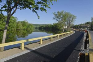
- In the downtown area a 1/4-mile section is completed at Young’s Field Park. It is known as the Riverwalk at Young’s Field. It is paved with an environmentally friendly, porous surface.
In 2018, Milone & MacBroom (now SLR Consulting) completed a Preliminary Engineering Report for the Town of New Milford for the remaining eight miles. For ease in completing the greenway in sections, their report breaks the remaining eight miles into Phases I through Phase 11 A. The Phases are not being completed in numeric order. Surfaces range from paved, soft trail, sidewalks, less-traveled roadway and boardwalk.
The Preliminary Engineering Report, Archaeological Study and Line Drawings can be seen here:
The overall conceptual map for the thirteen miles of greenway can be seen here:
The Western New England Greenway (U.S. Bike Rte 7)
The New Milford River Trail Greenway overlaps the Western New England Greenway (also known as U.S. Bike Route 7) in New Milford. The Western New England Greenway provides safe cycling route turn-by-turn directional maps that connect a series of existing trails and less-traveled roadways from La Route Verte at the Canadian border in North Hero, VT to the East Coast Greenway and Long Island Sound in Norwalk. Downloadable maps are available at https://wnegreenway.org/bike-routes/.
The U.S. Bicycle Route designation of the CT section of the Western New England Greenway happened at the meeting of the AASHTO Special Committee on U. S. Route Numbering on May 24, 2016. (Each state – CT, MA, VT – had different dates of designation.)
Connectivity to other Greenways/Trails
Besides connecting to the Still River Greenway, which connects to Danbury, the Norwalk River Valley Trail which ends in Norwalk, the New Milford River Trail Greenway will connect to other trails/greenways indirectly. In Norwalk, for example, the new 55-mile greenway will connect with the East Coast Greenway, a 3000-mile greenway that starts in Maine and ends in Florida. In Danbury, there will be connectivity to the Maybrook Trail, which is part of the Empire State Trail, which is 750-miles long and includes the Erie Canal Trail (which starts in Albany and ends in Buffalo, NY), The Champlain Valley Trail (that starts in Albany and ends in Canada) and the Hudson River Valley Trail (which starts in Albany and ends in NYC).